Tuesday was a milestone day for a couple of reasons: the odometer passed 6000 miles since we left home, and yesterday was also marked 2 months we've been on the road--Walter Boleman, are you reading this????? It was a great day in Arches National Park, a truly unique place. There are over 2000 catalogued arches in the park. The minimum size of an opening to be classified as an arch is 3 ft., and the longest is Landscape Arch, measuring 306 ft. in length. According to the orientation film we saw at the visitors center, the rangers are convinced that there are likely even more arches in the park that just have not yet been documented. And, of course, the forces of nature are slowly destroying some arches and creating new ones. Indeed, the film make the point that anyone visiting the park should definitely see Landscape Arch, as they don't know how long it will be there--in 1991 a 60 ft. long slab, 11 ft. wide and 4 ft. thick fell from the underside of this arch, leaving the thinnest part of the arch only 6 ft. thick. Amazingly, a visitor to the park that day captured this slab falling on video, and it was an incredible sight to see, as they incorporated it into the visitors center film.
Geologically, perhaps the major factor why there are all these arches here and not elsewhere is that the park sits on top of a massive underground salt bed, which formed over 300 million years ago when a vast sea flowed into the Colorado Plateau and then evaporated. Then, over time, residue from floods etc. left debris, which eventually compressed into rock. The unstable salt bed shifted and buckled over time causing huge uplifts to push up, forming domes, and leaving deep cavities, and great sections of rock fell into these holes. Faults led to vertical cracks, which eventually widened due to erosion, leaving long fins of pink Entrada Sandstone, and beige Navajo Sandstone. Water eventually penetrated the sandstone, and resultant freezing led to bits and pieces falling off, and the force of wind broke off more loose pieces--ultimately these fins were further eroded in places, thus leaving the arches. The orientation film made a very interesting point: the formations in Arches was the result essentially of the forces of rain water, while nearby Canyonlands, which we will visit next, was the result of river flow erosion. As scarce as rain is in this part of Utah, it's even more impressive to see how powerful the force of water is, to have caused all these unique formations over time.
There are a number of these arches that are famous and the subject of photographs you've likely seen over the years, e.g., Landscape Arch, Delicate Arch, the Windows, just to name a few. But beyond the most famous ones, there are arches everywhere, and each is simply fascinating to see. When you stand there and look at them, it's just an awesome thought to contemplate how long it took to form these intricate designs, each unique in its own way, and just incredibly beautiful. One thing that struck us, too, was that when you look at Landscape Arch and then Delicate Arch--which is the official state symbol, appearing on their license plates--you'd think that the names perhaps should have been reversed, as Landscape seems much more delicate. Then you realize that these were named many years ago, and often the name given by the first person to see a formation is what sticks--as one brochure put it, this was the result of "calling it as you see it." What one person sees may appear different than another, but the first name usually endures.
Anyway, we first hiked in to see Landscape--very impressive, but also terrifying to think of the people who were under there when the slab broke loose. The trail used to go directly under the arch, but that section has been closed since the slab fell. Saw some other arches along the way and on the hike back down, saw a beautiful, small section of a straight rainbow in the sky. No rain at the time, but the colors were quite striking, though somewhat hard to see in the pictures I took.
Stopped at many different viewpoints, offering spectacular views of different arches. One place also had the remains of a homestead built by a disabled Civil War veteran named John Wesley Wolfe in the late 1800's. The first house he built, when he first came to the area with his son, was very primitive, the brochure says, with a dirt floor. When his daughter and her family came a few years later, she was appalled at the primitive place, and convinced her father to build a "modern" house, with a wood floor. This is the house that's still standing, and when you see the pictures of this "modern" house, you can only imagine what the primitive house must have been!
Went on to see Double Arch and the Windows, a series of three arches, fairly close together, which are really impressive. From a distance, Double Arch seems big, but you really can't get a true sense of how big until you hike up to it. Just amazing! When we hiked up into the windows, the wind was really howling, and, as you'll see from a couple of the pictures, standing in the middle of the arch in the wind required some balance--and holding onto your hat! One young man was posing for a picture in one of the windows when the wind blew his cap off--he went down the rocks to retrieve it, and fortunately made it back safely, but it was pretty precarious.
Came back to Moab late afternoon, stopped by our wonderfully discovered health food store for a few more goodies and came back to the campground, where it actually rained during the evening! It was funny, when we first heard raindrops falling onto the roof, I dashed out to bring the recliners inside, and just as soon as I did that, the rain stopped; rained off and on into the night, but rain here is unlike rain at home. Here, as one of the cowboy poets back in Torrey joked, is usually a "one inch rain" a drop falls one place and the next drop falls an inch away! He told the story of a cowboy who had propped his double barreled shotgun against a fence and forgot it overnight. It rained during the night and when he went to retrieve it the next morning, one barrel was full of water, but the other barrel was dry! Anyway, this is the first rain of any kind we've seen in quite some time. And this morning, it does appear that it tamped down the masses of cottonwood "snow" on the ground.
Some pics from yesterday:
Beautifully colored Swiss chard from our friend in Torrey, right before it went into the morning smoothies!
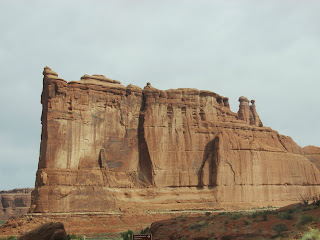
 Shots as we drove into Arches, and along the drive to the hiking.


 It's just amazing to see these balanced rocks, that look like they are about to fall any minute!


 Heading up the trail to Landscape Arch.
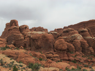
 Some shots showing some of the fins


First glimpse of Landscape Arch in the background
 More shots of Landscape


Tunnel Arch


Pine Tree Arch


 Layer of Navajo Sandstone on top of the Entrada Sandstone
 More fins--may one day become arches!

 A little hard to see, but the colors of the rainbow


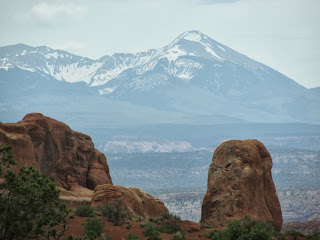
 Snow capped peaks of La Sal Mountains in the distance
White tops of Navajo Sandstone, at an area called Fiery Furnace


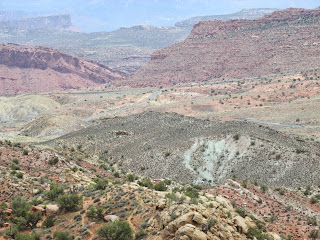
 Three shots showing evidence of the salt beds

 Delicate Arch


 Looks like an eagle!
 Wolfe Ranch
 Root cellar
 Looking into the "modern" one room house, with a real wood floor!

Double Arch


 Beautiful wild flowers along the trail


 Above and below: The Windows


 Turret Window


 Beautiful sky
 Balanced rock, against a sky with gathering "rain" clouds!

Geologically, perhaps the major factor why there are all these arches here and not elsewhere is that the park sits on top of a massive underground salt bed, which formed over 300 million years ago when a vast sea flowed into the Colorado Plateau and then evaporated. Then, over time, residue from floods etc. left debris, which eventually compressed into rock. The unstable salt bed shifted and buckled over time causing huge uplifts to push up, forming domes, and leaving deep cavities, and great sections of rock fell into these holes. Faults led to vertical cracks, which eventually widened due to erosion, leaving long fins of pink Entrada Sandstone, and beige Navajo Sandstone. Water eventually penetrated the sandstone, and resultant freezing led to bits and pieces falling off, and the force of wind broke off more loose pieces--ultimately these fins were further eroded in places, thus leaving the arches. The orientation film made a very interesting point: the formations in Arches was the result essentially of the forces of rain water, while nearby Canyonlands, which we will visit next, was the result of river flow erosion. As scarce as rain is in this part of Utah, it's even more impressive to see how powerful the force of water is, to have caused all these unique formations over time.
There are a number of these arches that are famous and the subject of photographs you've likely seen over the years, e.g., Landscape Arch, Delicate Arch, the Windows, just to name a few. But beyond the most famous ones, there are arches everywhere, and each is simply fascinating to see. When you stand there and look at them, it's just an awesome thought to contemplate how long it took to form these intricate designs, each unique in its own way, and just incredibly beautiful. One thing that struck us, too, was that when you look at Landscape Arch and then Delicate Arch--which is the official state symbol, appearing on their license plates--you'd think that the names perhaps should have been reversed, as Landscape seems much more delicate. Then you realize that these were named many years ago, and often the name given by the first person to see a formation is what sticks--as one brochure put it, this was the result of "calling it as you see it." What one person sees may appear different than another, but the first name usually endures.
Anyway, we first hiked in to see Landscape--very impressive, but also terrifying to think of the people who were under there when the slab broke loose. The trail used to go directly under the arch, but that section has been closed since the slab fell. Saw some other arches along the way and on the hike back down, saw a beautiful, small section of a straight rainbow in the sky. No rain at the time, but the colors were quite striking, though somewhat hard to see in the pictures I took.
Stopped at many different viewpoints, offering spectacular views of different arches. One place also had the remains of a homestead built by a disabled Civil War veteran named John Wesley Wolfe in the late 1800's. The first house he built, when he first came to the area with his son, was very primitive, the brochure says, with a dirt floor. When his daughter and her family came a few years later, she was appalled at the primitive place, and convinced her father to build a "modern" house, with a wood floor. This is the house that's still standing, and when you see the pictures of this "modern" house, you can only imagine what the primitive house must have been!
Went on to see Double Arch and the Windows, a series of three arches, fairly close together, which are really impressive. From a distance, Double Arch seems big, but you really can't get a true sense of how big until you hike up to it. Just amazing! When we hiked up into the windows, the wind was really howling, and, as you'll see from a couple of the pictures, standing in the middle of the arch in the wind required some balance--and holding onto your hat! One young man was posing for a picture in one of the windows when the wind blew his cap off--he went down the rocks to retrieve it, and fortunately made it back safely, but it was pretty precarious.
Came back to Moab late afternoon, stopped by our wonderfully discovered health food store for a few more goodies and came back to the campground, where it actually rained during the evening! It was funny, when we first heard raindrops falling onto the roof, I dashed out to bring the recliners inside, and just as soon as I did that, the rain stopped; rained off and on into the night, but rain here is unlike rain at home. Here, as one of the cowboy poets back in Torrey joked, is usually a "one inch rain" a drop falls one place and the next drop falls an inch away! He told the story of a cowboy who had propped his double barreled shotgun against a fence and forgot it overnight. It rained during the night and when he went to retrieve it the next morning, one barrel was full of water, but the other barrel was dry! Anyway, this is the first rain of any kind we've seen in quite some time. And this morning, it does appear that it tamped down the masses of cottonwood "snow" on the ground.
Some pics from yesterday:
Beautifully colored Swiss chard from our friend in Torrey, right before it went into the morning smoothies!


First glimpse of Landscape Arch in the background


Tunnel Arch


Pine Tree Arch


White tops of Navajo Sandstone, at an area called Fiery Furnace


Double Arch


No comments:
Post a Comment